Fremont's fire hazard severity zones
What the ordinance says
FMC Chapter 15.65 adopts the fire hazard severity zones recommended by CAL FIRE in 2025, and separately designates additional very high zones that the City identified itself. It was adopted by Ordinance 10-2025 section 1 on 15 July 2025. The chapter is short, five sections, and each one does a specific job.
"This chapter is intended to comply with the requirements of Cal. Gov't Code sections 51175 through 51189, and Cal. Pub. Res. Code section 4291(a), which require the city to adopt, by ordinance, the fire hazard severity zones designated by the California Department of Forestry and Fire Protection (CAL FIRE), which consist of very high, high, and moderate designations, subject to the city's authority to designate areas as very high fire hazard zones not otherwise designated by CAL FIRE."
Section 15.65.030 adopts the CAL FIRE recommended zones under Government Code 51178. Section 15.65.040(a) then designates additional very high zones beyond the State Fire Marshal's, on a finding supported by substantial evidence that the requirements of Government Code 51182 are necessary for effective fire protection, exercising the City's reclassification authority under Government Code 51179. The same subsection records that these additional areas were previously approved by the city council on 4 December 2007 under Ordinance 33-2007.
Section 15.65.050 preserves the City's authority to impose fire and public safety requirements more restrictive than the state minimum. In other words, Fremont has explicitly reserved the right to go further than Sacramento.
Which map counts
The legally operative map is the one labelled "City of Fremont, Local Responsibility Area, Fire Hazard Severity Zones" and dated 26 June 2025, per FMC 15.65.040(b). Any boundary you read off a different document is not the boundary the City is applying.
FMC 15.65.040(c) requires an official copy of that map to be kept on file with the city clerk's office, posted online on the fire department's website, and made available to the public at the fire department's administrative offices during regular business hours. Three access routes, written into the ordinance. Use one of them.
Two City published resources, both authoritative:
- The City's fire hazard severity zone address lookup viewer, linked from our resources page.
- The Very High Fire Hazard Severity Zones layer on the Fremont open data hub, for the underlying GIS data.
Avoid third party address lookup sites. They republish older boundaries, and the whole point of the 2025 ordinance is that the boundaries changed.
Geographically, the zones concentrate along Fremont's eastern hills, from the Mission Peak area south toward the Sunol border, with the Niles Canyon corridor inside the affected band. But zone boundaries are drawn at parcel resolution and do not follow neighbourhood names, so a street by street guess is not good enough.
Why Fremont's hills burn: the four month dry window
Fremont receives effectively no rain from June through September, about a third of an inch across all four months combined, with a July normal of zero. That is what turns the annual grasses on the hill slopes into cured fine fuel every single year, on schedule, without needing a drought to do it.
The full picture from the 1991 to 2020 climate normals at the nearest first order station is 16.00 inches of annual precipitation, with 13.08 inches, or 82 percent, falling between November and March. So the year has two distinct halves: a wet half that grows a heavy grass crop, and a dry half that cures it into fuel. A wetter than average winter does not reduce fire risk in Fremont. It increases the fuel load.
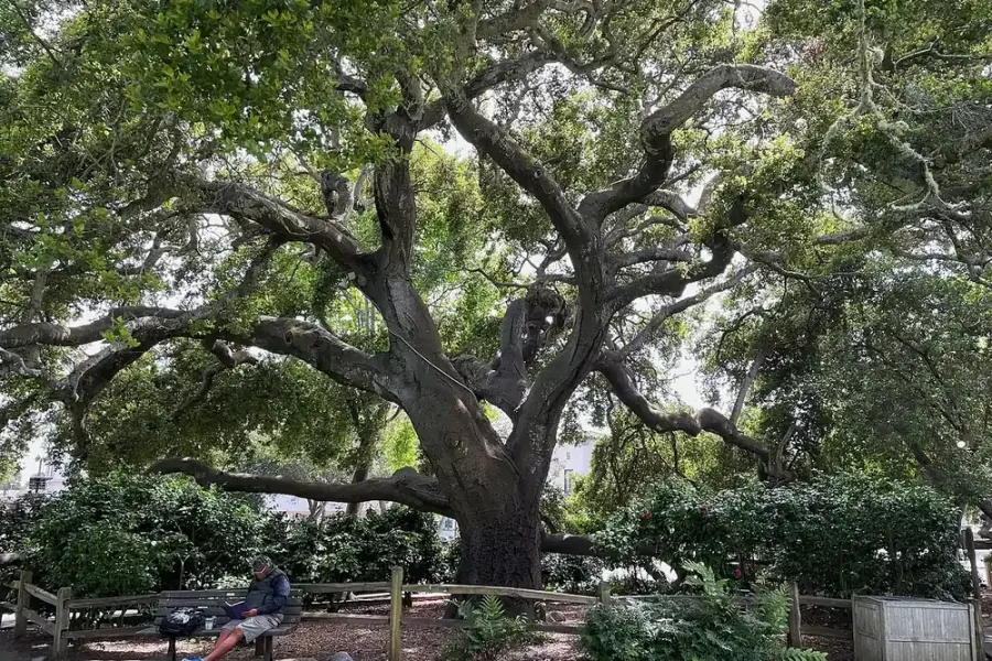
For trees specifically, the same cycle is why summer is a stress season. Established natives like coast live oak evolved for it and handle it well, provided nobody is irrigating their root collar. Non native trees on shallow hillside soils suffer, and a stressed tree is both a pathogen target and, once dead, a standing fuel. See oak tree care for the summer irrigation rules that matter most on a hillside lot.
What defensible space actually asks of your trees
Defensible space work on a Fremont hillside lot is overwhelmingly pruning and fuel separation, not tree removal, and a mature tree with a clean trunk and a separated crown is usually an asset rather than a hazard. People hear defensible space and picture a cleared lot. That is not what the framework asks for and it is not what a fire behaves like.
The tree related work that matters, in order of value:
- Clear tree debris off and around the structure. Roofs, gutters, under decks, against walls and fences. Ember ignition of accumulated leaf litter is the dominant structure loss mechanism in these fires.
- Get limbs off the roof and away from walls and chimneys. Ordinary pruning, high value.
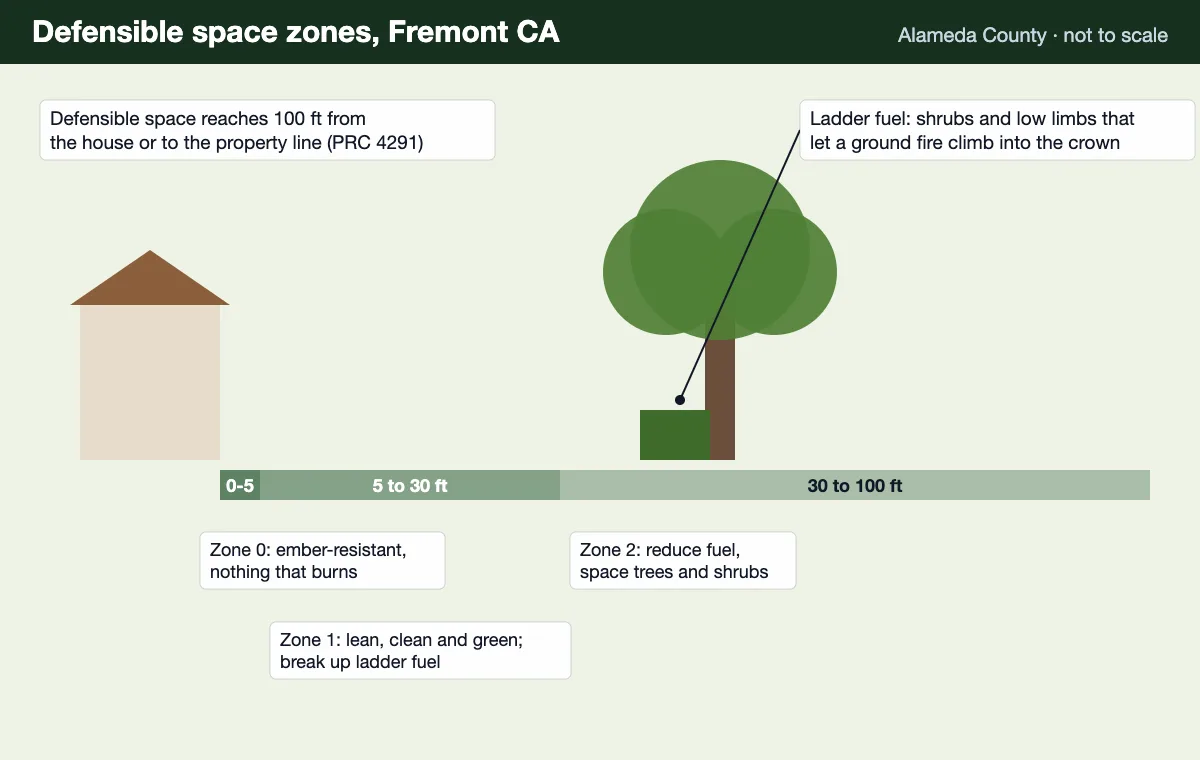
- Break ladder fuel continuity. Raise crowns and separate shrub masses from the tree canopy above them so a surface fire cannot climb.
- Separate tree crowns from each other where the canopy is continuous across a slope, so a crown fire cannot run unchecked.
- Remove standing dead trees within reach of structures. Dead wood is both fuel and a structural failure risk.
This work is done as defensible space clearing, and the practical version on most Fremont properties is a crown raise, a clearance prune off the structure, and a debris clear. It is not dramatic and it is what actually changes outcomes.
On specific clearance distances, ask the City
This site is deliberately not publishing specific defensible space clearance distances on this page, because California's detailed specifications are set by regulation and have been revised in recent rulemaking. A stale number republished on a contractor website is worse than no number, because people act on it.
California Public Resources Code 4291 is the statutory basis, cross referenced directly by FMC 15.65.020. The current clearance specifications sit in regulation beneath it. The Fremont Fire Department and the Office of the State Fire Marshal are the two authoritative sources for what your parcel needs today.
What can be said without qualification is how the zones are structured and which tree work matters, which is what the rest of this page does. Any quote for defensible space work on a Fremont property should confirm current requirements against the City before the scope is written, not after.
Direct links to the City's wildfire preparedness page, the fire hazard severity zone viewer and the open data layer are on our resources page.
How to work through fire hazard zone tree work on a Fremont lot
The first two steps establish whether the ordinance reaches your parcel. The rest are the tree work, in the order that actually reduces risk.
- 1
Look your address up on the City viewer
Fremont publishes an address lookup viewer for the fire hazard severity zones. Enter your address and note which zone, if any, the parcel falls in. Zones run moderate, high and very high. The City also publishes the underlying layer on its open data hub if you prefer the raw map.
- 2
Confirm against the adopted map, not a third party site
The legally adopted map is the one labelled City of Fremont, Local Responsibility Area, Fire Hazard Severity Zones, dated 26 June 2025. FMC 15.65.040(c) requires an official copy to be kept with the city clerk, posted on the fire department website, and made available at the fire department during business hours. Third party lookup sites republish stale boundaries.
- 3
Walk the first five feet around every structure
The zone closest to the building is the one that decides outcomes in an ember driven fire. Clear dead leaves and needles from roofs and gutters, from under decks, and from against walls and fences. Tree debris accumulating in these places is what puts embers in contact with the structure.
- 4
Assess limb clearance over and near the roof
Look for branches overhanging the roof, touching the walls, or growing into the chimney zone. These are the tree related items that most commonly need attention on a Fremont hillside lot, and they are ordinary pruning work rather than removal.
- 5
Break up ladder fuel continuity in the tree canopy
Ladder fuels are the continuous vertical path from grass to shrub to low limb to crown that lets a surface fire climb into the canopy. Breaking that continuity by raising crowns and separating shrub masses from tree canopies is the highest value tree work on a fire exposed Fremont lot.
- 6
Check the current clearance specifications with the City or CAL FIRE
California Public Resources Code 4291 sets the statutory defensible space framework and the detailed clearance specifications are set by regulation and revised periodically. Confirm the current numbers with the Fremont Fire Department or the Office of the State Fire Marshal rather than relying on any figure republished on a contractor site, including this one.
Fire hazard severity zone questions
Is my property in Fremont's Very High Fire Hazard Severity Zone?
Check your address against the City's fire hazard severity zones viewer or the layer published on the Fremont open data hub, because parcel level boundaries cannot be judged by neighbourhood. The zones in Fremont run along the eastern hills, from the Mission Peak area south toward the Sunol border, with the Niles Canyon corridor inside the affected band.
What is FMC Chapter 15.65?
FMC Chapter 15.65 is Fremont's wildland urban interface fire area ordinance, adopted by Ordinance 10-2025 section 1 on 15 July 2025. Section 15.65.010 states that the chapter shall be known as the wildland urban interface fire area ordinance, and the chapter adopts the fire hazard severity zones recommended by CAL FIRE in 2025 along with additional very high zones designated by the City itself.
What map does Fremont actually use?
FMC 15.65.040(b) identifies the map labelled City of Fremont, Local Responsibility Area, Fire Hazard Severity Zones, dated 26 June 2025. That is the legally operative map. Section 15.65.040(c) requires an official copy to be kept with the city clerk's office, posted online on the fire department's website, and made available to the public at the fire department's administrative offices during regular business hours.
Did Fremont have fire hazard zones before 2025?
Yes. FMC 15.65.040(a) records that the additional very high fire hazard severity zones the City designates beyond the State Fire Marshal's areas were previously approved by the city council on 4 December 2007 under Ordinance 33-2007. The 2025 ordinance replaces that earlier designation with the current zones and the 26 June 2025 map.
Can Fremont designate zones that CAL FIRE did not?
Yes, and it has. FMC 15.65.040(a) designates additional areas beyond those identified by the State Fire Marshal as very high fire hazard severity zones, based on a finding supported by substantial evidence that the requirements of California Government Code 51182 are necessary for effective fire protection. The City exercises that authority under Government Code 51179.
What does PRC 4291 defensible space require?
California Public Resources Code 4291 requires defensible space around structures in designated zones, and FMC 15.65.020 cross references it directly as one of the statutes the Fremont ordinance is intended to comply with. The detailed clearance specifications are set by regulation and have been revised in recent rulemaking, so confirm the current requirements with the Fremont Fire Department or the Office of the State Fire Marshal rather than relying on a figure from a contractor website.
Does being in a zone mean I have to remove my trees?
No. Defensible space is about managing fuel continuity, not about clearing trees. Most of the work on a Fremont hillside lot is raising crowns, separating shrub masses from tree canopies, clearing limbs off roofs and walls, and keeping dead material off the ground and out of gutters. Mature trees with clean trunks and separated crowns are generally an asset rather than a liability.
Why does Fremont's dry season matter for fire risk?
Fremont receives effectively no rain from June through September, with June to September totalling about a third of an inch combined and July normal precipitation at zero. Four rainless months cure the annual grasses on the hill slopes into fine fuel, and that cured grass is the ignition and spread medium that makes the eastern hills a wildland urban interface in the first place.
Can being in a zone affect my home insurance?
Insurers do consider fire hazard severity zone designation and parcel level hazard when pricing and underwriting California homeowners policies, though the specifics vary by carrier and by year. Documented defensible space work is worth keeping records of for that reason, including dated photographs and the contractor's written scope.
What are ladder fuels?
Ladder fuels are the continuous vertical path of burnable material that lets a fire on the ground climb into a tree canopy: grass into low shrubs, shrubs into low limbs, low limbs into crown. Breaking that vertical continuity is the single highest value tree action on a fire exposed lot, because a surface fire that cannot reach the canopy stays a surface fire.
Does the fire ordinance override the tree preservation ordinance?
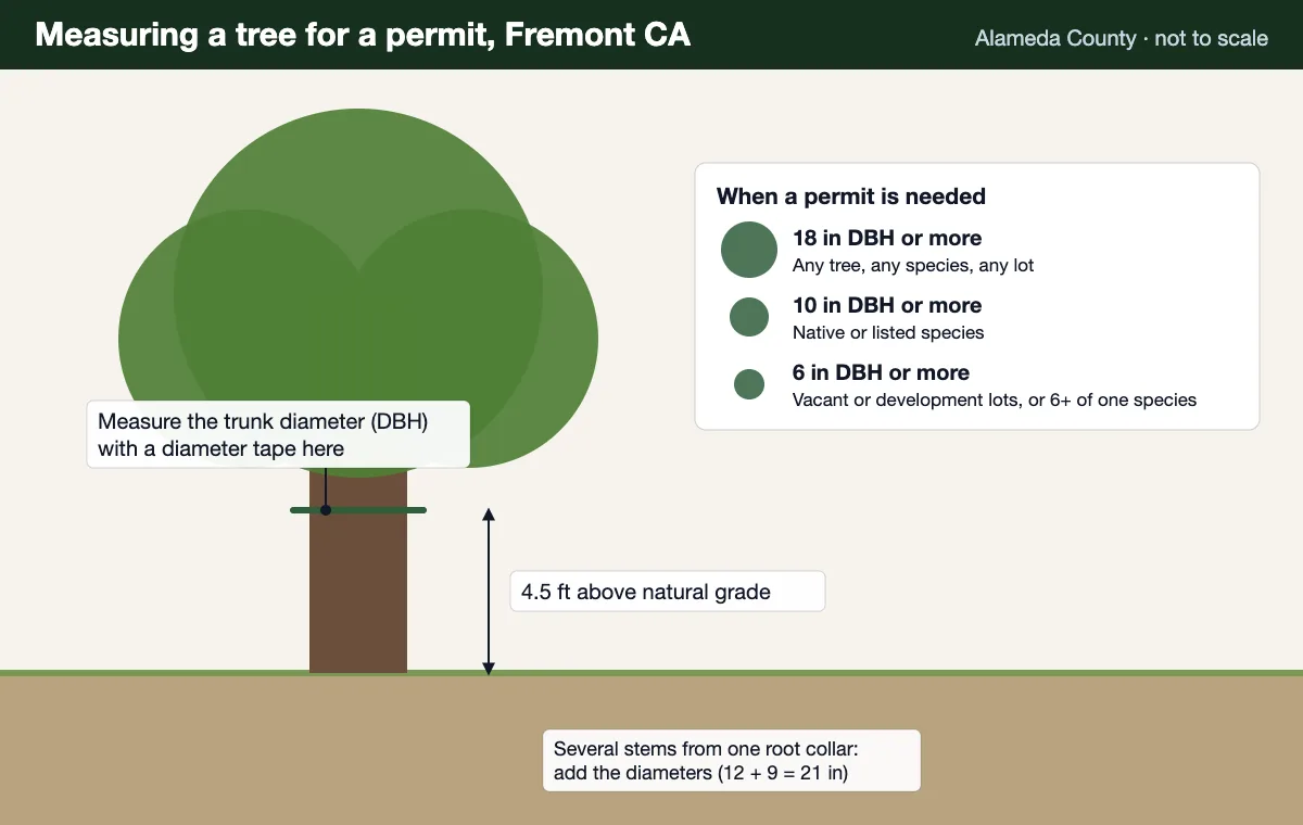
No, the two operate together. A tree in a fire hazard severity zone that is also 18 inches DBH or larger, or a native species 10 inches or larger, is still a protected tree under FMC 18.215 and its removal still goes through the City permit process. Defensible space work is usually pruning rather than removal, which is one reason it rarely collides with the tree ordinance.
Which Fremont neighbourhoods are affected?
The fire hazard severity zones concentrate along Fremont's eastern hills, running from the Mission Peak area south toward the Sunol border, with the Niles Canyon corridor within the affected band. Hillside parcels in the Mission San Jose district and along the Niles Canyon corridor are the ones most likely to fall inside a mapped zone, but the only reliable answer for a specific property is the City viewer.
Related Pages
Defensible space assessment for your Fremont property
Send the address for a free estimate. Check it against the City's current zone map and get a written scope that separates what the ordinance drives from what is simply good tree care.
- Free written estimate, no obligation
- Check whether your tree is protected before work starts
- Ask any crew for its CSLB license and certificate of insurance
- Mark storm damage as urgent in your request